

India is a federation composed of 28 states and 7 union territories. In 1956, under the States Reorganisation Act, states were reorganised on a linguistic basis. Since then, their structure has remained largely unchanged. Each state or union territory is further divided into administrative districts. The districts in turn are further divided into tehsils and ultimately into villages.
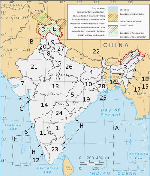
No. Of States in India
- · Andhra Pradesh
- · Arunachal Pradesh
- · Assam
- · Bihar
- · Chhattisgarh
- · Goa
- · Gujarat
- · Haryana
- · Himachal Pradesh
- · Jammu and Kashmir
- · Jharkhand
- · Karnataka
- · Kerala
- · Madhya Pradesh
- · Maharashtra
- · Manipur
- · Meghalaya
- · Mizoram
- · Nagaland
- · Orissa
- · Punjab
- · Rajasthan
- · Sikkim
- · Tamil Nadu
- · Tripura
- · Uttar Pradesh
- · Uttarakhand
- · West Bengal
U union territories : The union territories of Pondicherry and the National Capital Territory of Delhi, have elected legislatures and governments, both patterned on the Westminster model. The remaining five union territories are directly ruled by the centre through appointed administrators.
- · Andaman and Nicobar Islands
- · Chandigarh
- · Dadra and Nagar Haveli
- · Daman and Diu
- · Lakshadweep
- · National Capital Territory of Delhi
- · Pondicherry
No comments:
Post a Comment